|
 Ugarit
(Ras al-Shamra): Ugarit
(Ras al-Shamra):
About 10 - 13 km north of Lattakia; Ugarit has given the world its
first alphabet and stood as a very important, brave city of the
Phoenicians. It actively participated in trade around the eastern
Mediterranean and from here much of the later Phoenician commercial and
cultural expansion took its inspiration, not least through the
development of the alphabet. Ugarit is one of the few Bronze Age sites in the Middle East which
offers identifiable remains to the casual visitor and not simply to the
specialist scholar or those who have the time to familiarize themselves
with the wealth of published information extracted from the site.
Unlike other centers of the period, the palace and religious buildings
were built in stone. Whereas the mud and brick of cities such as Mari
and Ebla has quickly eroded with rain and wind on exposure to the
archaeologist's spade, Ugarit survived with at least its foundation
courses and a good deal of its walls clearly delineated in stone. Excavated almost continuously over the course of 50 years, Ugarit has
served as one of the anchor-points of modern archaeological research
and biblical studies illustrating in particular the Canaanite milieu in
which the Biblical world later emerged. The chance discovery of the
site in 1928 quickly confirmed the identity of the remains with Ugarit,
mentioned in the archives of Mari and of Tell a-Amarna in Egypt.
Exploration began in 1929 under French auspices and continued until
1970 under the direction of Claude Schaeffer. Marguerite Yon started
directing the excavations in the site after 1974. The earliest settlements at Ras Shamra go back much earlier 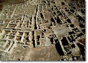 than Bronze
Age. Neolithic remains were found at the base of the Tell, dating from
the 7th millennium BC. The city, lying close to Cyprus, a rich source
of copper, shared in the general rise in sophistication of technology
and political organization in the area in the Early Bronze Age (3rd
millennium BC) and through trade was drawn into the orbit of the
Mesopotamian world. For the Mesopotamians, it offered access for their
goods, a source of permanent building materials (wood and stone) and a
point of contact with the wider Mediterranean world. than Bronze
Age. Neolithic remains were found at the base of the Tell, dating from
the 7th millennium BC. The city, lying close to Cyprus, a rich source
of copper, shared in the general rise in sophistication of technology
and political organization in the area in the Early Bronze Age (3rd
millennium BC) and through trade was drawn into the orbit of the
Mesopotamian world. For the Mesopotamians, it offered access for their
goods, a source of permanent building materials (wood and stone) and a
point of contact with the wider Mediterranean world. A dark age descended around 2200 BC. The city seems to have been burnt
and its population probably diminished. A new wave of immigrations in
the region, however, brought fresh infusions of population with the
coming of the Amorites around 2000 BC. The Canaanites, a
Semitic-language group from the south, formed the pre-dominant
population during the new millennium. Ugarit's commercial potential as the key point on the
Mediterranean/Mesopotamian route was fully exposed during the second
millennium. Economically, the city was developing when the Egyptians
turned to Ugarit as a source of timber and other imports. This golden
age saw the establishment of a local Ugaritic dynasty, whose authority
was underpinned by the balance struck between Egyptian power under the
XI and XII Dynasties (c2000 - 1800 BC) and Hammurabi's dominance in
Mesopotamia. 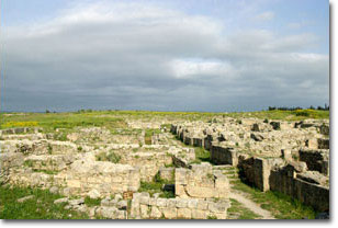
Even at the peak, the Kingdom of Ugarit did not control extensive
territory. The King's writ probably ran no further than the mountain
range directly behind the city and the land between the present Turkish
border to the north and Jeble. The city's prosperity was based on
agricultural riches of its hinterland and its trading role rather than
extensive political control. Ugarit flourished again in the Later Bronze Age (around 1600) after
Hyksos invasion of Egypt. Again, there were immigrations from Mitanni
and Hurrian elites, but the population remained basically Canaanite.
Ugarit recovered and was rebuilt after an earthquake and a tidal wave
hit the city in the mid 14th century BC. The subsequent golden age (14th - 13th centuries BC) accounts for much
of the building achievements now visible when the city benefited from
the Egyptian/Mitannian peace. The warehouses were overflowing and one
of the earliest alphabets greatly simplified record-taking and
accounting; thirty cuneiform symbols - that based on the principle of
"one sound, one sign" - were a much simpler method of recording
language than the unwieldy pictogram-based cuneiform. The archives
include: political dealings, tax and commercial accounts, religious
texts, diplomatic correspondence in Babylonian syllabic cuneiform, some
scholarly texts in Hurrian and a few in Cypriot-Minoan script. With remote power of the Hittites in Turkey by 14th century BC, Ugarit
King urges the Pharaoh to appease the Hittites with gifts. The 13th
century brought other changes, in particular links with the Aegean. The
city's rule was brought to an end after by the Sea Peoples invasion in
about 1200 BC that probably caused the destruction of the city's
palace-based economy. Consequently, the local economy probably reverted
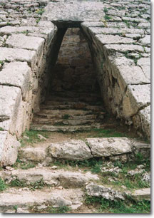
to a more traditional village-based system. The Fortress: There are only a few remains of the fortress, walls and postern gate
which once protected the palace complex. This defensive work had begun
in the 15th century BC. The city walls were formed by smoothing off -
at 45° - the slope of the mound created by preceding occupation layers
and covering this with a stone glacis. The latter was supplemented by a
bastion or tower protecting the official entry. The Main Palace: Dates from the second half of the Late Bronze Age phase of the city's
occupation (14th - 13th centuries BC). One can see the portico with two
pillar bases which mark the main entrance to the palace from the
bastion. The passageway from the entrance leads to a small
courtyard/reception area for guests from which the palace proper opens
to the south. The palace had over 90 rooms, 6 courtyards and archive
store. There were subsidiary palaces to the north and south of the main
palace complex. The Acropolis: It is 200 m high to the north east. There are two main temples on the acropolis: - Temple of Baal: Baal was the patron deity of the city. He represented strength,
fertility and control of the weather. The temple lies on the north
western side of the acropolis. Its plan consists of an open courtyard
with a central altar. Beyond this, the sanctuary is preceded by a
vestibule. The walls of the latter were extraordinary thick in order to
conceal internal staircases on three sides leading upwards to form a
tower rising above the cella (the sanctrum or the room which houses the
altar). - Temple of Dagon: Dagon was the god of fertility in Ugaritic pantheon. The temple's
outline can only be seen in the foundation remains but it follows much
the same basic plan as the Baal Temple though the walls are even
thicker. |

